Home                                  Table of Contents                                back to page 2

Fires shaping future of forest

It’s been called a 100-year fire, the worst in 95 years, prompting a declaration of emergency, the closure of more than 19 million acres of land, and costing millions to fight. But its toll, both ecologically and ethically, may prove to be a test of tolerance, one that could ultimately shape the future of forest management.

The debate has already begun. “Weather conditions are just one of a dozen factors that are affecting the severity of this fire season,” said Keith Olson, executive director of the Montana Logging Association. “Is this the most significant factor? Time will tell. But I would say no. I would say it’s neglect.”

However, accusations of neglect don’t sit well with those who say fire is a natural element, and that this year’s fires have only been amplified by severe drought.

“These fires have not been held to roadless lands and wilderness areas,” said John Gatchell of the Montana Wilderness Association. “These fires are burning for the most part in heavily managed lands that are riddled with roads, and that’s reflective of extreme conditions, not neglect.”

Regulations governing management policies

The Multiple-Use Sustained-Yield Act of 1960, along with individual forest plans, dictate how officials manage the forests under their charge. According to the act, multiple use entails the management of renewable “surface” resources, such as timber, within the Nation Forest so that “they are utilized in a combination that will best meet the needs of the American people.”

The act also says that sustained yield means maintaining a high level, or regular output, of renewable resources “without impairment of the productivity of the land.”

According to Dave Turner, public information officer with the Helena Ranger District, officials are bound by these laws when managing the land and its resources, as well as the management plan prescribed for each particular forest. “When we get new people, this plan provides continuity through time in how we manage the forest,” Turner said. “There is also national direction that comes out of our Washington office and, in a very basic way, all forest plans are similar because federal laws tell us how the forests will be used.”

Turner added that federal laws say the National Forest will be open to multiple uses, such as grazing, mining, timber, and other uses. But while such policies have been around for decades, this year’s fires could result in a change in management policies by influencing the debate on whether logging, in its many forms, is an appropriate tool in managing the forest and reducing the severity of fire.

It’s a question that both the logging association and the wilderness association are aware of. “This year’s fires may change some public attitudes,” Olson said. “But whether it changes public policies or not depends on what happens in Nov ember. Policy is an administrative desire, and who the public elects into office, and who’s in charge of various land management agencies, will be a deciding factor.”

However, Bob De cker of the Montana Wilderness Association said he believes that timber companies, allied by their congressional counterparts, may use this year’s fires as a tool to change both public opinion and management practices. “We know that the timber companies will probably attempt to log burned timber in an expedited salvage program, and will also attempt to change fundamental land management practices through fear of fire,” Decker said. “These fires are neither evil nor absolutely preventable, and people have to understand that they are raging in places that are heavily logged, roaded and developed, much more than they are burning in undeveloped roadless lands.”

Logging as a tool: Has it helped or hurt?

According to the National Interagency Coordination Center in Boise, Idaho, Montana’s two largest fires, the Valley Complex Fire in the Bitterroot Valley and the Toston-Maudlow Fire in the Big Belt Mountains east of Helena, are both burning in a variety of terrain. But a closer look, according to Gatchell, shows the Valley Complex Fire, currently measured at more than 155,000 acres, has burned 11,000 acres of land owned by the Darby Lumber Co. It has also burned areas roaded to a density of 6.6 miles of road per square mile of land. In areas of the Toston-Maudlow Fire, the blaze has burned through clear cuts without hesitation.

“You can see how the most heavily logged and roaded areas have burned with extreme intensity,” Gatchell said. “We were told for years this activity would prevent fires and that’s clearly not the case. If you open up the canopy and log the value off the land, you increase the chance of fire.” When commercially valuable timber – typically the larger trees – are removed from the forest and the forest canopy is opened, Gatchell said, the ability of the forest to hold moisture is reduced.

Flash fuels are exposed to the sun, the forest dries up and the land, Gatchell said, becomes brittle, capable of burning with increased intensity. “We should be managing to work in conjunction with the ecological circumstances that we aren’t able to change,” Gatchell said. “In many areas where the fires are burning, what we’re talking about is a very altered environment. It has roads, it’s been subdivided, and it’s been logged. However, the fire’s regime has not changed.”

According to Turner, that argument has been around for a long time. As a result, the question entertained by Olson and Gatchell comes with no easy answers. “It’s really a case-bycase, forest-byforest basis, whether logging is an appropriate tool to manage fire,” Turner said. “We’ve run into the question of clear cuts, and in my best professional view, clear cutting is a harvesting technique and a way to thin and manage the forest, but it’s an emotional issue. If your occupation were to grow trees for harvest, it’s a very practical, useful and efficient way to harvest those trees. The logging industry would ascribe to that.”

Despite the efficiency of clear cutting when used for timber harvesting, however, the question of whether it adds to or detracts from the severity of fire may depend on how the clear cut is left. “If you clear cut a unit and do not remove the slash, certainly, when that stuff cures, that’s compacted fuel and it can aggravate a fire and make that fire burn more intensely,” Turner said. “But when that stuff is removed, you have a large break in continuous fuels.”

That large break in the forest, which may or may not hinder the ability of fire to spread, is why there aren’t more clear cuts scattered about the state – they are publicly unpopular. “From an economic standpoint, you can understand how clear cuts appeal to the forest industry,” Turner said. “But there’s not much doubt in my mind that other visito rs to the forest see those clear cuts as being massively ugly. All through my career, they’ve been a big question.”

Are changes in store in the wake of the fires?

Though Turner cannot say whether this year’s fires – the worst in nearly 100 years – will change public opinion, it may alter the way the Forest Service does business. “It may speed up the way we’ve been doing business the last 10 years,” Turner said. “We’ve been doing less and less clear cutting over the last 10 years, and our biggest sale comp onent has become selective cutting and thinning, and that seems to be publicly favored.”

Turner said fuel buildup, the aging of the forest and this year’s fires will all likely result in larger thinning projects. But will those projects involve removing smaller, unmarketable fuels, or the larger merchantable trees? If it’s an argument concerning reducing the risk of fire and doing what’s best for the forest, as Gatchell said, the logging industry should remove the smaller ladder fuels, while leaving the larger trees behind. However, for an industry concerned, at least in part, with profit, removing the small trees for the sake of the larger ones does the industry little good. It’s becomes an economic argument which Turner understands.

“Leaving the larger trees – that’s a hard one to pull off economically, because the industry wants the big ones,” Turner said. “They have merchantable fiber. When you take the younger trees, the economic value is not there. You have to mix the economic value.” But should managing the forest to protect it from fire be rooted in pure economics? As it turns out, everything, once again, falls back on policy and public opinion.

“My answer to that would have to come from a legal standpoint,” Turner said. “Should the forest be used as a commodity or a scenic backdrop? That’s a question for society. What would have to happen for us to deviate from the law would take congressional action. Congress would have to pass a series of laws.” And while the fire’s continue to rage across the state, and while officials estimate the worst is yet to come, both the Montana Logging Association and the Montana Wilderness Association say it may be too soon to take sides. “We’re trying not to get into the rhetorical portion of this thing at this time,” Olson said. “There will be plenty of time for that.” “It’s unwise to get sharply critical or complicated with analysis at this point,” Decker said.                              By MARTIN J. KIDSTON, IR Staff Writer

Back


Western Montana wildfires update

Here's an update on fires burning Saturday in Western Montana. Predicted winds of up to 40 mph in Montana may challenge fire lines on the large fires.

 Bitterroot fires

BLODGETT TRAILHEAD, 10,745 acres, three miles northwest of Hamilton. Higher relative humidities moderated fire activity until mid-afternoon. Efforts are concentrated on keeping the fire from crossing Canyon Creek and moving toward communities west of Hamilton. Much of the western perimeter has hit natural barriers and is not spreading.

VALLEY COMPLEX, 184,750 acres, seven miles south of Darby. The Army's 3rd Battalion 327th Infantry from Fort Campbell, is assigned. The complex consists of the Bear, Taylor, Taylor Spot, Hilltop, Razor, Fat and Mink fires. The Valley and Mussigbrod complexes have burned together. Air quality has improved enough to allow earlier reconnaissance helicopter bucket work. The precipitation received on Thursday hasn't had much effect on fire activity. At least 700 homes are still evacuated.

SKALKAHO COMPLEX, 59,511 acres, 10 miles southeast of Hamilton. Included in the complex are the Bear, Coyote and Skalkaho Falls fires. Fire activity has increased on the north slopes. Fireline in one division was overrun, and crews were pulled off the fir eline. Residents of Sleeping Child and Little Sleeping Child have been allowed to return home under a two hour evacuation notice.

WILDERNESS COMPLEX, 58,500 acres, 14 fires in the Selway-Bitterroot and Frank Church River of No Return Wildernesses, 40 miles southwest of Hamilton. Fire activity has been moderate, due to increased winds, higher temperatures and lower relative humidities throughout the fire area. Large fires in the complex include the Hamilton, Lonely, Fitz, Thirty, Echo and Throng fires.

CROOKED, 4,801 acres, 50 miles southwest of Missoula, near Lolo Pass. The team is also managing 10 other fires, most of which are in the Selway-Bitterroot Wilderness.

 Missoula area

THOMPSON FLAT COMPLEX, 12,168 acre s, six fires in the vicinity of Superior. Crews and dozers continue to construct fireline and perform mopup on Johnson Creek and Flat Creek. Structure protection operations in Trout Creek and Quartz Flat are ongoing. A number of spot fires along the east flank are being worked in an effort to keep the fire from establishing itself in the Sunrise Creek drainage.

UPPER NINEMILE COMPLEX, 19,630 acres, 25 miles northwest of Missoula. Spot fire activity has been noted approximately 3/4 mile northeast of the Siamese fire. Fireline has been lost on one division of the Ninemile fire and two divisions of the Alpine fire.

RYAN GULCH, 17,118 acres, 15 miles east of Clinton. Structure protection, road closures and evacuations are still in effect for Garnet Ghost Town and residences at the north end of the fire along Bear Creek. A power line and a communications site are also threatened.

CLEAR CREEK DIVIDE COMPLEX, 18,919 acres, 60 miles northwest of Missoula. Consists of the Clear Creek, Vanderburg, Siegel, Seepay an d Magpie Creek fires. Strong winds and low relative humidity have caused the upper portions of the Seepay and Magpie fires to make downhill runs. The potential for communities along Highway 200 to be threatened still exists.

SCHLEY, 438 acres, eight miles south of Arlee. The main fireline and a contingency fireline are complete. Rehabilitation of dozer lines is in progress.

MONTURE/SPREAD RIDGE, 22,800 acres, 15 miles east of Seeley Lake. Several new starts have been discovered in the general area. Crews working to keep fire spread on the Monture fire south of Lodgepole Creek, and on the Spread ridge fire from crossing Spread Creek. Rolling material continues to be the primary cause of fire spread on both fires.

MIDDLE FORK COMPLEX, 38,820 acres, consists of the Falls Creek, Cougar Creek/Coyote Springs/Medicine Lake (CCML), Skalkaho Pass, Lick Creek and Cooper Creek fires, 30 miles southwest of Philipsburg. The Cooper Creek fire has burned into the Mussigbrod fire. The CCML fires have progressed to Signal Rock.

Northwest Montana/Flathead

KOOTENAI COMPLEX, 10,681 acres, 20 miles northwest of Libby. Three new starts have been discovered and successfully initial attacked. Work continues on the contingency fireline from the Kelsey-Can fires north to Okaga Lake. All fires are relatively quiet no substantial growth.

STONE YOUNG, 21,800 acres, 65 miles northeast of Libby. With the inversion lifting, fire activity has rapidly increased. The fireline has held despite strong winds. Spots located outside the fireline have been suppressed.

TROY SOUTH, 4,150 acres, a complex of fires near Troy. Twenty three fires have been controlled and are in patrol status.

GREEN MOUNTAIN, 763 acres, seven miles northwest of Trout Creek. The complex includes the Green Mountain, McNeeley, Basin Creek and Engle fires. The fires are creeping in heavy duff. Personnel assigned to this fire are providing initial attack on new star ts in the area.

CHIPMUNK, 2,200 acres, burning in spruce, subalpine fir and brush 45 miles southeast of Kalispell. The fire is moving toward the east with significant activity observed in the more heavily forested portions of the fire. Continual spotting to the north is a concern.

HELEN CREEK, 6,000 acres, 22 miles south of Spotted Bear. The fire is actively backing to the west and south with minimal movement to the north. There is a potential threat to four structures, but fire movement is being monitored by U.S. Forest Service personnel. The fire is approaching the Mud Lake Lookout and a test of structure protection measures may occur today.

MINARET PEAK, 275 acres, near the Spotted Bear Ranger Station in the Bob Marshall Wilderness. The rate of spread is slow and the fire is backing. From The Missoulain

Back


Fire fighters trying to ‘hold what we've got’ at Red Lodge

The Willy Fire south of Red Lodge that exploded Sunday afternoon and has burned 3,500 acres "will last weeks, not days," a forest service official told a public meeting today.  Rand Herzberg, Beartooth Forest district ranger, said the blaze in heavy timber on the west side of Highway 212 has forced the evacuation of 100 to 150 homes in the Rock Creek and West Fork of Rock Creek drainages. Highway 212 over the Beartooth Pass remains closed.

He said four bulldozers worked through the night to construct a fire line two miles south of Red Lodge from Highway 212 to the West Fork of Rock Creek. Additional heavy equipment is arriving this morning to help in fire line construction.  Twenty-eight fire engines, including six Forest Service units, are in place to protect threatened structures.

"This is going to be a tough one, folks," Herzberg told the 300 people gathered at the Red Lodge Civic Center. “We'll not be in suppression mode today. We're going to try and hold what we've got,” with the goal to keep the fire on the west side of the highway.  He said firefighters expect “a long drawn-out, testy trial. It is going to last weeks, not days.”

“This is not in the bag by any means, folks,” he said. He said homes in the threatened drainages will remain evacuated as a precaution and officials will be “stingy” about letting residents in to retrieve belongings. Officials said that erratic fire behavior, steep slopes and gusty winds are preventing a direct attack on the fire with ground personnel. Fire management specialists are expected to arrive late Tuesday or Wednesday morning. Air tankers dropped retardant on the mountain Sunday and were expected to return Monday afternoon.

The American Red Cross has set up an assistance center at the civic center in downtown Red Lodge. The Beartooth Nature Center has offered to care for stranded pets.

Back


The fire was named for Willie Nelson

RED 
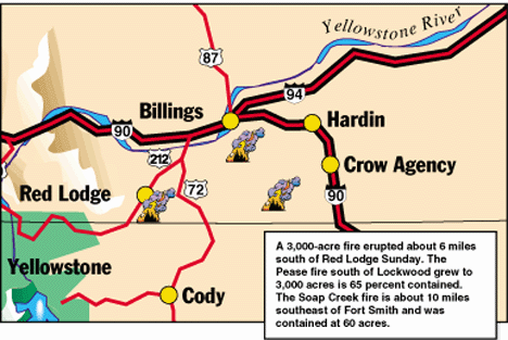
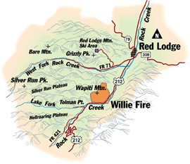
LODGE – The fire everyone feared erupted Sunday afternoon within eight miles of Red Lodge, destroying more than 3,000 acres in its first hours.

As many as 150 homes were evacuated along the Rock Creek drainage in the Beartooth Mountains. Officials pleaded for help from every firefighter within driving distance, said Scott Fitzwilliams, an U.S. Forest Service information officer. “We’re scrambling to get the resources we need. It’s a serious situation,” Fitzwilliams said. “There’s obvious threats to residences.”

The fire ignited at about 4:30 p.m. after a motorcycle crashed on the Beartooth Highway south of Red Lodge, a Montana Highway Patrol dispatcher said. By 5 p.m., the fire had exploded to 400 acres, racing up the steep slopes of Wapiti Mountain. Three hours later, the fire had grown to 3,000 acres. The fire, named the “Willie” fire by Forest Service officials, jumped from treetop to treetop so quickly that ground crews had no chance of snuffing the fire in its first minutes, said Jeff Gildhaus, U.S. Forest Service fire information officer.

The fire was named for Willie Nelson, whose concert drew about 3,000 fans to the Home of Champions Rodeo Grounds a half mile west of Red Lodge. Carbon County Sheriff Luke Schroeder said homes in Tipi Village and Wapiti Valley along the road to the Red Lodge Mountain ski resort were evacuated Sunday evening. Cabins and homes along the West Fork drainage of Rock Creek were ordered closed nearly four weeks ago. The Main Fork of Rock Creek was closed Thursday.

8_28firemap.gif (50466 bytes)Because of the heavy smoke and failing light, the exact direction of the fire was not known Sunday at 9 p.m., Schroeder said. “If it crests the mountain and gets in the West Fork area, we could have much more trouble,” Schroeder said. “It’s been a real concern of ours for some time. There’s a tremendous amount of fuel in the West Fork drainage. The terrain is so steep it would be extremely hard to get crews to it.

The Beartooth Hospital and Health Center in Red Lodge readied “tentative plans” for evacuation according to a hospital spokeswoman. No evacuation had taken place as of 10 p.m. The American Red Cross has opened a relief center at the civic center in downtown Red Lodge, Red Cross official Adela Awner said. The center, at 14th Street and Oakes Avenue, will provide evacuees with a place to sleep and breakfast.

Five air tankers were sent to the fire at about 6 p.m., according to the Billings Interagency Dispatch Center. Each plane carried 2,000 gallons of fire retardant. “We have five air tankers in the air right now,” Gildehaus said. “That’s pretty good considering the great need there is for air support all over the place.” Gildehaus said the fire was a “crown fire,” which moves from treetop to treetop.

“We can only fight it from the air,” Gildehaus said. “We just can’t put our people on the ground right now. The fire is not going in a good direction right now. It’s threatening a lot of homes and could split and head down a ridge and threaten some more homes.”

Gildehaus said every rural fire engine in the area has been set up around homes in the Rock Creek area. He said there was no property damage so far.

With the Beartooth Highway closed, tourists caught on the other side of the pass had to find another way back to Billings. “We’re moving everybody back toward Yellowstone Park, telling them to turn around,” an MHP spokeswoman said. At a roadblock at the Piney Dell turnoff south of Red Lodge, police stopped Lyle and Cindy Dunham, who have owned a home in the canyon for 23 years.

Last Wednesday, the family was evacuated when the Custer National Forest was closed for fear of a fire. They were able to collect a few armloads of photo albums, mementos and were able to get their animals boarded in Red Lodge.

“Now, we’re wondering if we got enough stuff out Wednesday, like our financial records and stuff we can’t replace,” Cindy Dunham said. “It’s just a horrible feeling to be shut down like this (at roadblock).” She said she a bad feeling when they closed the forest Wedensday, but “I didn’t think it would really happen. It’s just awful.”

At the Willie Nelson concert, David and Michelle Glick had hoped to dance the afternoon away. Instead, they stood anxiously on the top row of a south grandstand where they could keep en eye on the smoke billowing just a few miles away. The couple was visiting from Jackson Hole, Wyo., and had rented a house in the Rock Creek area for the weekend especially to see the concert. All of their suitcases and a second car were at the rental house, which police wouldn’t let them return to. Compounding their problems was the uncertainty of where they would spend the night. All of the hotel rooms in Red Lodge were booked for the music festival.

“We feel bad for the owner of the house and we feel bad for the animals up there,” Michelle Glick said. “We’ve been waiting all summer to see Willie and this has sure taken the fun out of it.”

Back

Tourist attractions closed by fires

Two of Montana's most popular tourist attractions have been closed to public access by forest fires. The Montana Department of Transportation closed U.S. Highway 212 over the Beartooth Pass between Red Lodge and Cooke City, Mont., because of the Willie fire near Red Lodge. The highway itself is being used as a fire line and there is poor visibility because of smoke. Traffic along the popular corridor to Yellowstone National Park is being rerouted through Wyoming.

Near Butte, fire restrictions have closed tours to Our Lady of the Rockies. The statue overlooking Butte from atop a mountain will still be lighted at night, but smoke could interfere with visibility at times. Our Lady Executive Director Gene Frechin says that only maintenance personnel will be allowed up to the base of the statue.

Back

Lightning sparks Cyclone Ridge fire in the Flathead

KALISPELL – Despite blustery weekend winds, fire activity in northwest Montana was relatively quiet, with few new starts and only scattered spotting across active fire lines. Throughout the region, crews attacked new fires sparked by a Thursday night lightning storm, held lines on existing fires and cut new fire line around many of the area’s largest fires.

In Glacier National Park, a handful of new starts were well under control Sunday, and the Parke Peak Fire continued to burn across about 2,100 back country acres.

On the Kootenai National Forest, the Stone-Young Complex of fires burned a bit closer to homes southwest of Eureka, with the Lydia Fire spotting across Pinkham Creek. Those spots, however, were quickly snuffed.

The Troy South Complex of fires remains a high priority on the Kootenai, with crews paying special attention to the O’Brien, Callahan Creek and Taylor Peak fires. Of the 41 fires burning across 4,200 acres in the Troy South Complex, 26 are considered under control.  The 54 fires burning on the Kootenai Complex have covered nearly 11,000 acres, with 33 fires contained and 19 controlled.

The Chipmunk Peak Fire, burning on the Flathead National Forest, has spread to 2,500 acres and is within five miles of about 70 structures.

Elsewhere on the Flathead, a new lightning fire spread quickly Saturday, fanned by strong dry winds. Called the Cyclone Ridge Fire, the blaze grew from seven acres Saturday morning to more than 100 acres Sunday afternoon.

Firefighters working the Cyclone said flames would climb into the crowns of trees, throwing hot embers into the wind from on high. Those embers, then, would drift down out in front of the fire, starting new spots as they touched down.

This “leap-frog” activity made the fire especially difficult to control, despite the two helicopters, four water-equipped skidders, two water tenders, one dozer and more than 20 firefighters working the blaze.

Wilderness fires on the Flathead include:

  • The Helen Creek Fire: Located 25 miles south of Hungry Horse Reservoir in the Bob Marshall Wilderness, this fire is active at 6,500 acres.
  • The Minaret Peak Fire: At 300 acres, this fire is growing relatively quickly 13 miles south of the reservoir.
  • The Monture Fire: About 4,000 of this 16,000-acre wildfire is burning on the Flathead National Forest, approximately 45 miles south of the reservoir.

Throughout northwest Montana, several land closures and fire restrictions are in place.   By MICHAEL JAMISON, of the Missoulian

 Back


8/29/2000 Fire Updates
Predicted winds could hamper firefighters

Predicted strong winds in Montana on Tuesday will present challenges for firefighters on the large fires. Here is a rundown on the status of Western Montana’s wildfires as of Tuesday morning.

Bitterroot-area fires

VALLEY COMPLEX, 177,850 acres, seven miles south of Darby. The complex consists of the Bear, Taylor, Taylor Spot, Hilltop, Razor, Fat and Mink fires. The Fat and Taylor fires have grown due to winds. Fire activity has increased on most of the other fires also. Poor visibility is hampering aerial support and reconnaissance flights. At least 700 homes are still evacuated.

SKALKAHO COMPLEX, 61,543 acres, 10 miles southeast of Hamilton. Included in the complex are the Bear, Coyote and Skalkaho Falls fires. Increased activity has been observed on the north slopes. Protection of structures in Skalkaho, Sleeping Child, Little Sleeping Child and the east side of Old Darby Road remain the priority.

BLODGETT TRAILHEAD, 10,745 acres, three miles northwest of Hamilton. Fire activity has again been light, with smoldering and creeping through unburned fuels with little open flame observed. Helicopters have been utilized to keep the fire out of the Sheafman Creek and Canyon Creek drainages.

WILDERNESS COMPLEX, 60,250 acres, 14 fires in the Selway-Bitterroot and Frank Church River of No Return Wildernesses, 40 miles southwest of Hamilton. Large fires in the complex include the Hamilton, Lonely, Fitz, Thirty, Echo and Throng fires. Helicopter bucket work has been initiated on the Lonely fire to reduce spread near the Magruder Ranger Station.

CROOKED, 4,801 acres, 50 miles southwest of Missoula, near Lolo Pass. Burnout operations on the south flank of the fire are continuing. Some isolated torching has been observed on the interior of the fire, but otherwise activity has been minimal overall.

MUSSIGBROD COMPLEX, 70,491 acres, 12 miles northwest of Wisdom. The complex includes the Mussigbrod and Maynard fires which have now burned together. Efforts have been initiated to strengthen the fireline by burning the interior grass and sage fuels.

Missoula-area fires

THOMPSON FLAT COMPLEX, 14,065 acres, six fires near Superior. A burnout operation along the northeast portion of the Flat Creek fire has been slowed due to increasing winds developing in the area. Structure protection continues in the Trout Creek and Quartz Flat areas.

UPPER NINEMILE COMPLEX, 22,452 acres, 25 miles northwest of Missoula. Indirect fireline construction on two divisions of the Ninemile fire should be complete in one or two days. All firelines on the Alpine fire are holding and mopup operations are continuing.

CLEAR CREEK DIVIDE COMPLEX, 19,818 acres, 60 miles northwest of Missoula, consists of the Clear Creek, Vanderburg, Siegel, Seepay and Magpie Creek fires. Crews are maintaining fireline west of Magpie Creek and securing fireline along the south side of the Vanderburg fire. The fireline constructed by dozers on the Upper Sepay fire is holding.

RYAN GULCH, 17,118 acres, 15 miles east of Clinton. Crews are making good progress with mopup and rehabilitation operations. Helicopter bucket drops have been used on the Alder Creek fire.

MONTURE/SPREAD RIDGE, 25,500 acres, 15 miles east of Seeley Lake. Winds have been relatively calm. The northern and northeast portions of the Crimson, Monture and Spread fires continue to grow. Crews are holding the southern edge of the Spread fire and constructing fireline on the western flank of the Monture fire.

MIDDLE FORK COMPLEX, 23,400 acres, consists of the Falls Creek, Cougar Creek/Coyote Springs/Medicine Lake (CCML), Skalkaho Pass, Lick Creek and Cooper Creek fires, 30 miles southwest of Philipsburg. Fuels are burning actively with single and group torching continuing throughout the afternoon. Short crown runs, mainly in the interior and on the Skalkaho Pass fire, have been observed. The acreage reduction is due to counting only that portion of the Coyote fire which is on the Beaverhead-Deerlodge National Forest. The rest of the Coyote fire is being counted as part of the Skalkaho Complex.

ALDER CREEK, 4,300 acres, 31 miles southeast of Missoula. Fire activity has primarily been in the fire's interior. The fire movement is backing down to Rock Creek.

SCHLEY, 438 acres, near Arlee. No new information was reported.

Northwest Montana fires

KOOTENAI COMPLEX, 11,995 acres, 20 miles northwest of Libby. Crews have initial attacked the North Grizzly fire and will suppress the West Grizzly fire today.

STONE YOUNG, 24,460 acres, 65 miles northeast of Libby. Spotting across firelines is continuing in the area of Pinkham Creek Road. Calmer weather and higher humidities are aiding suppression efforts. No major spots have been located outside the firelines. On the Cliff Point fire, construction of indirect firelines has been completed and a burnout operation is in progress.

TROY SOUTH, 3,400 acres, near Troy. Torching and occasional short runs are causing short range spotting and some fire growth. Crews continue to patrol, suppress and mopup the Studebaker Draw, Kadsie Creek, O'Brien, No See Um, Frezkat East and West fires. Mopup operations continue on the Pulpit and Taylor Peak fires.

CHIPMUNK, 2,765 acres, burning in spruce, subalpine fir and brush 45 miles southeast of Kalispell. The fire continues to move east with slowed fire activity occurring as the fire encounters lighter fuels. Spotting to the north is a concern. The fire received .03 inch of rain overnight.

GREEN MOUNTAIN, 841 acres, seven miles northwest of Trout Creek. The complex includes the Green Mountain, McNeeley, Basin Creek and Engle fires. No new information was received.

CYCLONE RIDGE, 200 acres, 35 miles north of Kalispell. No fire growth was observed on Sunday. Then the fire jumped containment lines on Monday and has grown to its current size.

SHARON, 450 acres, near North Fork in Glacier National Park. The fire continues to spread actively to the southeast. Passive torching and spotting has been noted. Winds are hampering suppression efforts.

HELEN CREEK, 6,000 acres, 22 miles south of Spotted Bear. The fire is actively backing to the west and south with minimal movement to the north. Four structures are threatened, but the threat to the Mud Lake Lookout has been reduced. The fire is being monitored by U.S. Forest Service personnel.

MINARET PEAK, 472 acres, near the Spotted Bear Ranger Station in the Bob Marshall Wilderness. No significant fire activity has been reported.

PARKE PEAK, 2,100 acres, Glacier National Park. The fire has been burning since July 23 in the northwest corner of the park. No significant fire activity has been reported.

CRIMSON PEAK, 240 acres, in the Bob Marshall Wilderness. The fire is backing into Young's Creek drainage. The rate of spread is being monitored by U.S. Forest Service personnel.   From The Missoulian

 Back


Tough fight lies ahead - Knocking down Willie fire will take weeks

RED LODGE – Favorable winds Monday kept the 3,000-acre Willie fire south of Red Lodge from making any major runs, but Beartooth District Ranger Rand Herzberg told community members that the fire was going to be difficult. “This is going to be a tough one, folks," Herzberg told more than 300 people who gathered for a briefing Monday at the Red Lodge Civic Center. The community can expect “a long, drawn-out testy trial. It’s going to last weeks, not days," he said. “This is not in the bag by any means."

About 150 homes evacuated Sunday night in advance of the fast-moving fire remained empty Monday with no immediate word on when residents could return. But the Forest Service was allowing some to return to their homes to collect a few necessities, like medication or pets. No structures in the area of this mountain resort town had burned as of Monday.

Carrie Purcell and her 5-week-old daughter, Rebecca, were turned away at a roadblock Monday morning after they tried to return to their home. Purcell, who lives in Tipi Village, said she was in Billings when she heard about the fire, but by the time she got to Red Lodge Sunday, it was too late reach her home. Purcell said she begged the sheriff to let her go in and she grabbed clothes for her husband and two sons but forgot clothes for herself and baby. “In all the chaos, I didn’t have time to get formula," she said.

Highway 212 – the Beartooth Highway – between Red Lodge and the Chief Joseph Highway remains closed.

During the community meeting, Herzberg, along with Mayor Brian Roat and Carbon County Sheriff Luke Schroeder, discussed plans for the fire and tried to give worried residents an idea of what to expect.

The Willie fire – named after country singer Willie Nelson who performed Sunday night in Red Lodge – started about 4:30 p.m. when a motorcycle crashed on the Beartooth Highway near the Westminster church camp south of Red Lodge. The fire spread to 2,000 acres in heavily timbered, steep slopes within one and one-half hours, said Jeff Gildehaus, a fire information officer with the Forest Service.

Herzberg said a big break came during the night when winds shifted from the usual down-canyon direction to an up-canyon direction, effectively slowing the fire’s march south toward Red Lodge.

Back


Willie fire more active on Tuesday

RED LODGE - Higher temperatures and low humidity stirred up the 3,000-acre Willie fire south of Red Lodge Tuesday, although winds generally continued to blow up-canyon and away from the community that was threatened by the blaze two days ago.

About two-thirds of the 150 homeowners who had been evacuated from two drainages also were allowed to return to their homes while others were permitted a few hours to collect necessities and to reduce fire hazards around their homes, said Jeff Gildehaus, a fire information officer.

Also Tuesday, a specially-trained fire management team of about 30 persons began taking over management of the fire from local officials at the Custer National Forest’s Beartooth Ranger District. Team members arrived Monday night and by Tuesday were setting up a fire command center at the fairgrounds and assuming operations to fight the fire. Fire managers began assessing homes in the Rock Creek and West Fork of Rock Creek drainages for fire protection.

Gildehaus said the Willie fire was “definitely more active" Tuesday because of the warmer temperatures, which were in the 80s, and the drier conditions. However, the fire made no big runs, and winds generally favored keeping the fire from spreading toward Red Lodge.

The Willie fire was among 31 large fires on 670,230 acres in Montana on Tuesday, the National Interagency Fire Center in Boise, Idaho, said. The biggest accounted for almost 250,000 acres after the Valley Complex and the Mussigbrod fires in the Bitterroot Valley burned together.

The seven fires in the Valley Complex had more than 200 miles of uncontrolled perimeter, the Forest Service said.

The 5,000-acre Pease fire, burning about 10 miles south of Billings on the Crow Reservation, burned Tuesday within its boundaries without significant expansion, said Jean Claybo of the Billings Interagency Dispatch Center.

Crews had the blaze 90 percent contained Tuesday night. The fire started Saturday night south of the Emerald Hills on U.S. Highway 87 East and raced over 3,000 acres in 12 hours.

Nationally, there were 84 fires on 1.7 million acres. So far this year, 6.2 million acres in the United States have burned, the Boise center said.

The Willie fire started about 4:30 p.m. Sunday when a motorcycle crashed about six miles south of Red Lodge on U.S. Highway 212 - the Beartooth Highway. Sparks from the wreck ignited tinder-dry grasses along the ditch. The fire spread to 2,000 acres in 90 minutes and reached 3,000 acres Sunday night, prompting officials to evacuate about 150 homes in the Rock Creek and West Fork drainages. Gildehaus said the evacuation was voluntary but some people refused to leave.

The fire is located near Wapiti Mountain in steep, rocky and timbered terrain. No structures have burned.

Air tankers continued their assault on the blaze, dropping retardant on the southern flank and along the ridge line. Fire officials are trying to keep the fire from cresting the ridge and coming down in the West Fork drainage. Another major concern is keeping the fire on the west side of Highway 212, which serves as a kind of fire break between the fire and many homes located on the banks of Rock Creek. The highway from Red Lodge to Chief Joseph Highway remains closed.

Volunteer firefighters from area communities continued to stand guard along Highway 212 in case the fire decided to make a run. In one area, the fire actively, but slowly, burned down the slope toward the road. Ground fires threw off billows of smoke as grasses burned while individual trees suddenly burst into flames. The crackling and popping of wood burning could be heard from the road.

To assist with fire fighting, fire managers have ordered fourteen 20-person hand crews, seven bulldozers, 15 engines and 8 helicopters. As many as 40 engines from area volunteer fire departments, the Forest Service and Montana Department of State Lands have responded to the fire.

Potential bulldozer operators went through the paces Tuesday by taking a conditioning test in which they had to walk one mile in 16 minutes. More than a dozen dozer operators, some wearing cowboy boots and hats, strode quickly down the middle of the road past the ranger district office.

Tuesday morning, Carbon County Sheriff’s deputies drove evacuated residents to their homes and waited as they gave them about 20 minutes to gather necessities. By late morning, Sheriff Luke Schroeder announced to a crowd gathered at the shuttle area set up in the parking lot of the Church of Jesus Christ of Latter-day Saints that the roadblocks were being moved farther up the road to enable some residents to return home.

Schroeder said he and Carbon County commissioners met Tuesday morning and agreed it was important to get residents back to their homes. For those unable to return home, it was important to give them time to protect their homes, he said. “We wanted to go through all the agencies to make sure we’re not putting people back in danger," he said.

Housing areas where people were allowed to return included Tipi Village and Wapiti Valley on the Ski Run Road and Grizzly Peak off of Palisades Road. In the Rock Creek drainage, residents living from the Point of the Rocks north to Red Lodge also could return.

Tom Kuntz, chief of the Red Lodge Rural Fire Department, urged residents to make their homes more fire proof by scattering wood piles, clearing fuels, cleaning gutters and closing curtains or shutters. Kuntz also cautioned residents they still may need to leave in a hurry and to be ready to go. “We may shut it down anytime," he said. Kuntz supported allowing residents back in on a limited basis. “People were getting antsy to check on their stuff," he said.

Don and Nancy Hamilton, who have a home in Tipi Village, were among those who were escorted by a sheriff’s deputy into their house Tuesday morning. They turned on their sprinkler while they collected items. Deciding what to take was “an interesting decision," Don Hamilton said. The couple took mostly photo albums, some computers disks that contained financial records and randomly grabbed clothes. “I picked up an overripe tomato," Nancy Hamilton said. “It’s sort of crazy. We’re concerned, but probably not as much as people on the Main Fork."

Dave Pauli, of the Humane Society of the United States, also was assisting residents whose pets were left behind in the commotion of Sunday. “Pet rescue has been going smoothly," he said. The society gave away a lot of cat boxes, leases and food Tuesday morning. Pauli even had battery operated aerators in case electricity went out and someone had a fish tank. “We’ve been through it enough times," he said. Two veterinarians from Laurel East Veterinary Service also voluntarily checked pets. Pauli said there hasn’t been a big need to shelter displaced pets but that so far, two guinea pigs, one Japanese fighting fish and one chameleon have been placed in a shelter.

The Willie fire was among 31 large fires on 670,230 acres in Montana on Tuesday, the National Interagency Fire Center in Boise, Idaho, said. The biggest accounted for almost 250,000 acres after the Valley Complex and the Mussigbrod fires in the Bitterroot Valley burned together.

The seven fires in the Valley Complex had more than 200 miles of uncontrolled perimeter, the Forest Service said.

The 5,000-acre Pease fire, burning about 10 miles south of Billings on the Crow Reservation, burned Tuesday within its boundaries without significant expansion, said Jean Claybo of the Billings Interagency Dispatch Center.

Crews had the blaze 90 percent contained Tuesday night. The fire started Saturday night south of Emerald Hills on U.S. Highway 87 East and raced over 3,000 acres in 12 hours.

The town of Wolf Creek was put on alert for possible evacuation Tuesday night after a new wildfire broke out at 2:30 p.m. about a mile away and grew to 150 acres by 7 p.m.

The fire burned uphill across steep terrain from a quarry southeast of town between Interstate 15 and Holter Lake, about 30 miles north of Helena near milepost 226, a Helena National Forest spokesman said. Helicopters dropped water on the blaze’s north flank to keep it out of town, and no evacuations were ordered as of 9:30 p.m. Tuesday. 

Back


Rain is a godsend

RED LODGE – A light rain fell on Red Lodge Wednesday afternoon, cooling the Willie fire in the mountains south of town as firefighting crews began building a fire line around the 2,500-acre blaze.

Sisters Shirley MacNamara and Bobbie Lair, who are among those evacuated from the Main Fork of Rock Creek, called the rain “God sent." The women – along with Lair’s husband, Gale, and their two small dogs, who also are sisters – spent a few hours Wednesday protecting their neighboring homes in the Four Hundred Ranch subdivision. Homeowners in the subdivision still are not allowed back in but can spend a few hours a day protecting their property. MacNamara scattered her wood pile, and the Lairs turned on six sprinklers – both precautions they learned from fire officials.

The fire began Sunday when a motorcycle crashed six miles south of Red Lodge on Highway 212 – the Beartooth Highway. Sparks from the accident ignited grasses near Wapiti Mountain, and the fire spread to an estimated 2,000 acres in 90 minutes. About 150 homes in the Main Fork and West Fork of Rock Creek were evacuated Sunday night. No structures have burned, and about two-thirds of the homeowners have been able to return home.

The fire previously was estimated at 3,000 acres but was revised to 2,500 acres Wednesday after aerial mapping. The Willie fire so far has cost about $250,000, according the Northern Rockies Coordination Center.

At a community meeting Wednesday morning at the Red Lodge Civic Center, Incident Commander Steve Frye, who heads a fire command team brought in to manage the fire, called the Willie fire “as complex as any we’ve encountered this summer."

But with Wednesday’s low winds, higher humidity and cloud cover, Frye said, “I feel we’ll be able to get a serious amount of business done on the Willie fire." The National Weather Service in Billings said that .01 inches of rain fell on Red Lodge Wednesday, and predicted a 30 percent chance of rain today.

Another community meeting is set for 10 a.m. Friday in the Red Lodge Civic Center. Frye, who is the chief ranger at Glacier National Park and came to Red Lodge from fires in the Bitterroot Valley, said the fire is complex because of the side canyons, high peaks, fuels, winds and the number of homes in the area. Frye said the strategy is to protect the community and homes and to build lines around the perimeter of the fire. The fire is about one-quarter to one-half mile north of the Sheep Creek tract of summer homes on its southern perimeter.

The Willie fire is the region’s top priority for resources after initial attacks, Frye said. “We’ll get the resources we need," he said. Four crews totaling 80 firefighters Wednesday worked on building a line from a bulldozer track near the fire’s north boundary, which is closest to Red Lodge. Fire engines from area volunteer fire departments continued to guard along Highway 212, which is acting as a fire line in the scenic canyon.

Six air tankers have been dropping retardant on the ridge line to keep the fire from spreading into the West Fork drainage, a strategy that has been working so far. The rain temporarily grounded the tankers.

Additional equipment includes a heavy-lift helicopter known as a skycrane, which has tanks and a hose that can fill a 2,000-gallon tank in 40 seconds, and a medium-lift helicopter.

Fire officials plan to shuttle more firefighting crews by helicopter to a large meadow near the top of 9,436-foot Wapiti Mountain. From there, the crews can continue to build lines along the western and southern perimeters. The elevation gain from the dozer line on the north end to Wapiti Mountain is about 3,000 feet. Frye said he has 15 outstanding orders for crews, which are 20-person firefighting teams.

The perimeter of the fire, including about three miles along Highway 212, is about 81/2 miles long. Building a line means cutting down trees to create a space where branches no longer interlock – between 6 to 10 feet – and clearing the ground of fuels in an area about 2 feet wide.

Fire can spread from tree to tree along the crowns and along the ground by burning grasses or downed timber. Fires also can be spread by spotting, which is when embers carried in plumes drop out and spark fires as far as one and one-half miles away, Frye said.

Fry complimented the Custer National Forest’s Beartooth Ranger District, which managed the fire until the specialized team arrived. “They did all the right things," he said. “That’s incredibly important to us."

Frye said he did not know when all residents evacuated would be able to return home but said he may know more in a few days.

Highway 212 continues to be closed from Red Lodge to the gate at Long Lane on the west side of the Beartooth Pass. Frye said he did not know when the highway would be opened to the public but that it probably will be opened soon with traffic led by a pilot vehicle.

Back


Website Design and Hosting courtesy of DataCorp